I. Introduction
In engineering measurement, the calculation of internal data accounts for a very important proportion. The accuracy and speed of calculation of internal data directly determines whether the measurement work can be completed quickly and smoothly. The calculation method of the internal data and the precision it needs to achieve are directly dependent on the instruments used in the field, the specific lofting targets and the office software and calculation methods used in the internal calculation. Computer Aid Design (also known as AutoCAD) is an emerging technology application developed in the early 1980s. It is now widely used in various fields. It greatly improves the efficiency of engineering and technical personnel. AutoCAD works with AutoLisp language, and can also compile some commonly used calculation programs to get the calculation results. AutoCAD's features provide another new and straightforward graphical calculation method for measuring internal data calculations.
Combined with the Leica total station we are currently using, it can easily measure three-dimensional coordinates, through the internal calculation of AutoCAD, 1, in the process of stakeout, you can use the programming calculator combined with the total station, very Convenient and fast work; 2, using AutoCAD to verify the results of the calculation; 3, with the promotion and popularization of the total station, polar coordinate lofting has become more and more popular among many methods of lofting The coordinate calculation is the key point and difficulty in the polar coordinate lofting. Because of the general red line lofting, the elements in the engineering loft are mostly points, straight lines (segments), circles (arcs), etc., so you can make full use of the set coordinates of AutoCAD. The functions of the department, drawing and taking points, as well as the functions of the calculators used in our field, greatly reduce the intensity of our work in the field and the workload of the industry. The following is an example of the construction of the Yele power plant area pivot project to illustrate the application of the three in engineering survey.
Second, the survey area overview
The site of Yele Power Station is located in Nantun Village, Liziping Township, Shimian County, 11KM from the dam site and 40KM from Shimian County. The plant hub project mainly includes ventilation tunnel, traffic tunnel, outlet tunnel, tailwater tunnel and tailwater open channel, main plant, auxiliary plant, installation room and pressure pipeline, busway, substation and other sub-projects. The underground cave is nearly 1,600 meters long. It involves the installation and positioning of two (single unit 120,000 kw) units. The elevation of the measurement area is between 1990 and 2200 meters above sea level, the height difference is large, and the temperature difference between the night and the inside and outside of the hole is large, which brings certain difficulties to the measurement operation.
Third, AutoCAD's typical internal data calculation and management
Encrypting control points in the survey area often uses angle-angle intersections or ranging intersections or a combination of the two. If we use mathematical formulas to calculate, it is very cumbersome and difficult to check for errors, such as dangerous rounds in resections. on. On the contrary, if we use AutoCAD to plot calculations, it is much simpler. The two methods of angle measurement and ranging are described as follows:
1. Forward angle measurement meeting:
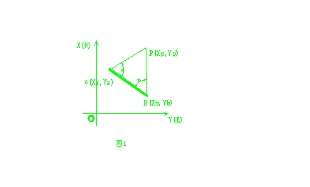
As shown in Fig. 1, A and B are control points with known coordinates, P is the point to be determined, and angles a and b have been observed at two points A and B.

We can use AutoCAD system software to draw two points A and B on the desktop according to the coordinates of A and B. Connect AB point to get AB line segment, then rotate AB line segment a and b angle with point A and point B respectively. (The direction can be visually distinguished from the figure). Use the ID command to select the intersection point P, you can get the P point coordinates. If the graph has a check condition, the coordinate difference can still be calculated. If the need is met with an approximate adjustment, the average calculation can be performed on the graph and marked.
Next page
Heat Lamp With Hexgonal Shade,Heat Lamps With Shade,Gold Hexgonal Shade Heat Lamp,Heat Lamp With Lamp Shade
Shaoxing Biaoyi Hardware Products Co., Ltd. , https://www.byeob.com